To access the preferences windows, select 'Preferences' from the 'Edit' menu bar at the top of the window.
Click on the preference to be taken to the help section of that option.
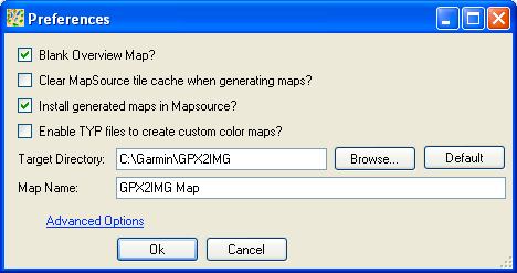
Mapsource uses the overview map to display an overview of the detailed maps in its coverage area. The overview map is never sent to your GPS unit and is only used in Mapsource.
If while viewing your maps in Mapsource, you notice that your track lines are often doubled up with one being less detailed than the other, you are seeing your overview and detail maps at the same time. To prevent this, enable the Blank Overview Map? option. (Note: you may notice with this setting enabled, you have to zoom in further on your map for the tracks and POIs to appear)
To increase the speed at which Mapsource displays maps which it has loaded previously, it generates caches of the maps at different zoom levels.
If you find you are still seeing old map details after generating an updated map in GPX2IMG, ensure this option is enabled and it will delete the old map cache info when generating new maps.
Some newer Garmin GPS units allow you to load IMG files directly to the unit without Mapsource. If you don't have Mapsource installed or don't wish to use it, check this option and GPX2IMG won't try to install its generated maps into Mapsource.
This option allows you to change between using the standard track types and colors as defined by your GPS unit, or using custom track colors as defined by a TYP file you load into GPX2IMG. For more details on using custom track colors and TYP files, see the TYP Files/Track Colors help section
This is the location where the IMG files GPX2IMG creates will be generated into. By default, this is a GPX2IMG folder placed in the directory where Mapsource is installed.
This option defines the name of the map product created in Mapsource.
When changed, this is the name that you must select in Mapsource in the drop down menu to show your created maps.
Clicking this link shows the advanced option which allow you to edit the zoom levels for your map detail and overview IMG files. See Zoom Levels for more details.