The Advanced Options section in the Preferences panel gives access to setting the zoom scales where your generated maps will be visible on your GPS unit.
Unfortunately, due to the way each GPS model interprets this data, as well as certain settings on the GPS unit (eg declutter, detail level, max zoom, etc) the distance values do not correlate exactly to zoom levels. The distance numbers listed in this section are for guidance only. To determine exactly how the zoom levels are interpreted with your maps and your GPS unit, trial and error is the only option.
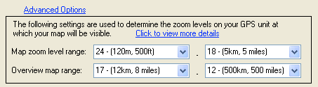
The zoom level ranges determine the zooms at which your map is visible. In the screenshot above, maps will be visible when the GPS unit is zoomed in at levels where the scale is between 120m and 5km (or 500ft and 5 miles). The overview map will appear in Mapsource when the map scale is between 12km and 500km (the overview map is never transmitted to the GPS unit, only used in Mapsource).
This table gives the approximate correlation of zoom levels to map scale:
Zoom Level |
Scale (metric) |
Scale (Imperial) |
24 |
120m |
500ft |
23 |
200m |
800ft |
22 |
500m |
0.3 miles |
21 |
800m |
0.5 miles |
20 |
2km |
0.8 miles |
19 |
3km |
2 miles |
18 |
5km |
5 miles |
17 |
12km |
8 miles |
16 |
20km |
20 miles |
15 |
50km |
50 miles |
14 |
80km |
80 miles |
13 |
200km |
200 miles |
12 |
500km |
500 miles |