In GPX2IMG you can edit the waypoints in your GPX file. In your IMG file and on your GPS unit, these points show up as POIs (points of interest).
After loading a GPX file, you will see something like the screenshot below on your screen. The data contained will be different based on your GPX file and the info in it, but the general concept is the same.
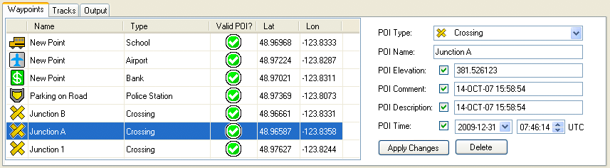
The data shown in the waypoint table is:
Waypoint Symbol: |
This is the symbol that will appear on your GPS unit to represent the POI. |
Name: |
This is the name of the POI and will appear in searches and while hovering over the POI. |
Type: |
This is a the text version of the waypoint symbol. |
Valid POI?: |
There are some GPX waypoint types that do not have an equivalent type of POI. If your waypoint is one of these types, an |
Lat: |
The latitude where the waypoint is located. |
Lon: |
The longitude where the waypoint is located. |
Selecting a waypoint from the list will: 1) Highlight it on the map view, 2) Fill in the info boxes on the right side of the screen with the data relating to that waypoint.
Poi Type and Poi Name are required fields. All other fields are optional.
To include data for the optional fields, check the checkbox for the field and provide the necessary info for that field. To remove a data field that is already included, just uncheck the check box for that field.
If you make any changes to the POI data, you must press the "Apply Changes" button to store the changes. If any changes are made to POIs or tracks, you will be asked to save your GPX files when removing the GPX file from GPX2IMG or when closing GPX2IMG.
You can also delete a POI by clicking the "Delete" button.
The optional fields do not have any effect on the generated POI and are only stored in the GPX file for informational purposes.
Editing Type of Multiple POIs
It is possible to edit multiple POIs at once by selecting more than one waypoint in the list by either holding the Ctrl button on the keyboard while selecting multiple items, or by selecting one item, holding the Shift key and selecting the last item in a sequential list.
With multiple waypoints selected, you can edit only the waypoint type.